
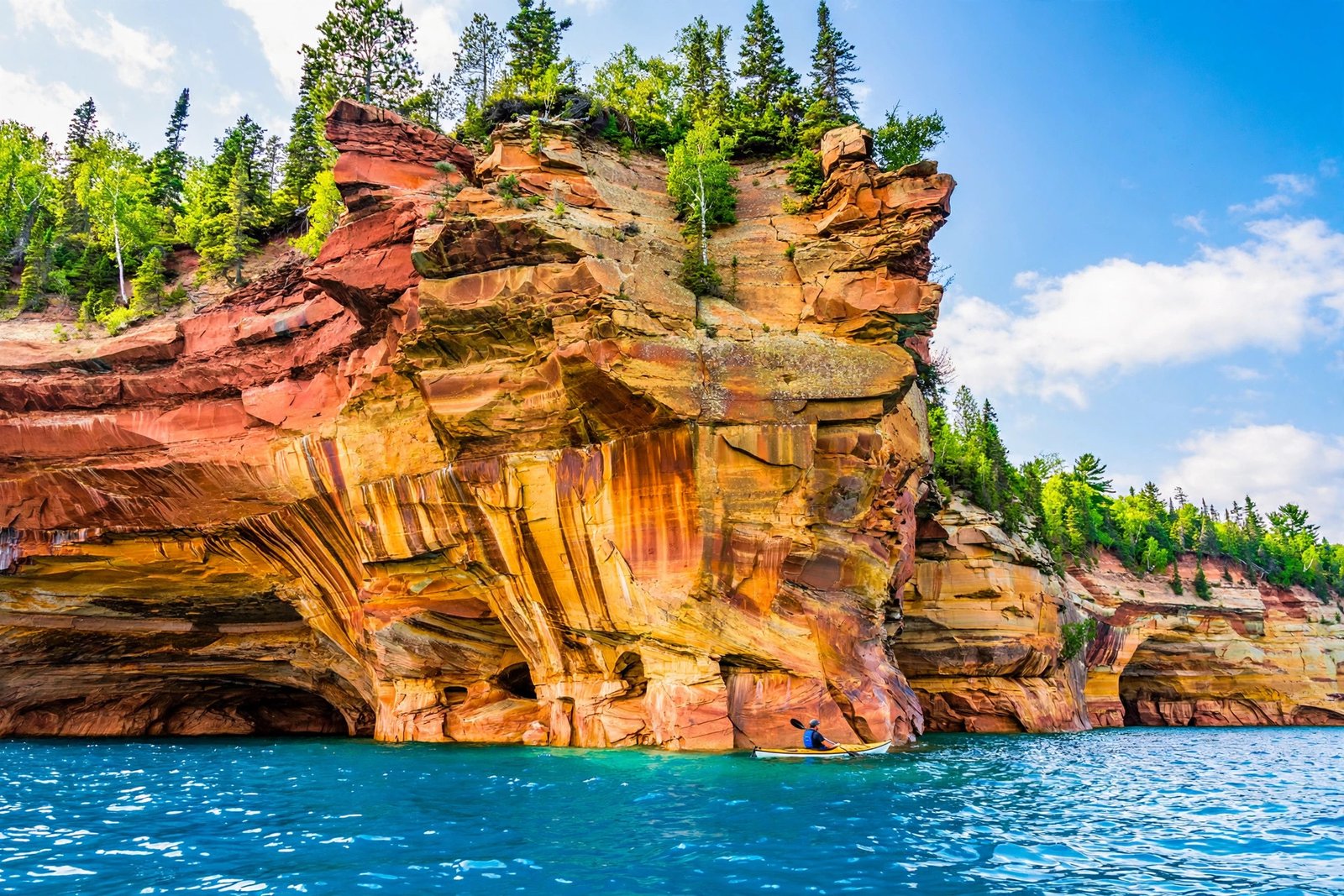
Along the southern shore of Lake Superior, in Michigan’s Upper Peninsula, a wall of sandstone rises out of the largest freshwater lake on Earth — and it is painted. Reds, oranges, golds, greens, and whites streak down cliffs up to 200 feet tall, colored by minerals seeping through ancient rock. This is Pictured Rocks, and it is one of the most beautiful shorelines in America. It is also, remarkably, one of the least crowded.
Pictured Rocks National Lakeshore was authorized by Congress on October 15, 1966, as America’s first National Lakeshore. It protects 42 miles of Lake Superior shoreline between the towns of Munising and Grand Marais, including 15 miles of the multicolored cliffs that give the place its name. The cliffs are made of sandstone from the Munising Formation, rock laid down some 500 million years ago in the Cambrian Period, and stained by groundwater carrying iron, copper, manganese, and other minerals. Iron makes the reds and oranges. Copper makes the greens. Manganese makes the blacks and whites. The result looks less like geology and more like a painting — which is exactly how the place got its name.
What Makes the Cliffs So Colorful
The color is not paint, and it is not lichen. As groundwater drips down the cliff faces, it carries dissolved minerals out of the sandstone and deposits them in streaks. Each mineral leaves its own color, and because the water follows different paths year after year, the patterns shift. The cliffs never look the same twice. After a rain, the colors deepen. In low autumn light, the whole wall glows.
The rock itself is soft sandstone, which is why the cliffs are carved into arches, caves, and castle-like towers. Miners Castle is the most famous formation, a turreted outcrop that once had two stone sentries before one collapsed into the lake in 2006. Chapel Rock is another icon, a lone white pine growing from a sandstone pillar connected to the mainland by a natural arch, its roots visibly reaching across the gap for soil. Grand Portal was once a massive arch some 300 feet across before it partly collapsed in the early 1900s. The landscape here is always changing, and the Park Service is clear about it: the cliffs are undercut by waves, rockfalls happen, and visitors should stay back from the edges.
The Best Way to See Pictured Rocks Is From the Water
You can hike the clifftops — and you should — but the full scale of the place only hits you from a boat. From the water, the cliffs rise straight out of Superior’s blue-green depths, and you can see the arches, caves, and color bands at eye level. Boat tours run from Munising from late spring through fall, and kayaking the shoreline has become one of the most popular ways to experience the park, though Lake Superior is cold, deep, and famously unforgiving, and guided trips are the smart choice for most paddlers.
From land, the North Country Trail runs along the clifftops for miles, with overlooks that put you hundreds of feet above the lake. The Chapel Loop, about 10 miles, is the classic day hike, taking in Chapel Rock, Chapel Falls, and Mosquito Beach. Shorter walks reach Miners Castle Overlook, Miners Falls, and the Log Slide, a towering sand dune on the park’s eastern end where visitors can climb down to the lake — and face a steep, sandy climb back up. The Grand Sable Dunes rise nearly 300 feet above the water, some of the tallest freshwater dunes in the world.
Waterfalls, Dunes, and a Lake Like an Ocean
The cliffs get the attention, but Pictured Rocks is a whole landscape. Waterfalls pour over the sandstone in several places, including Miners Falls, Chapel Falls, and Spray Falls, which drops directly into the lake. Inland, the park holds forests, lakes, and beaver ponds. At the eastern end, the Grand Sable Dunes stretch for five miles, a vast sand plain left behind by a glacial lake, with dune summits as high as 275 feet above the water.
And then there is the lake itself. Lake Superior is the largest freshwater lake in the world by surface area, and it behaves like an inland sea. Its water is famously cold — rarely above the mid-60s even in summer — and its storms are legendary. The lake’s moods shape everything here, from the fog that rolls over the cliffs in the morning to the ice that coats the shoreline in winter. Superior’s cold water is also why the cliffs are so well preserved: the lake freezes the shoreline in winter and keeps the rock cool and stable through the summer.
The Shipwrecks Beneath the Cliffs
What most visitors never see is what lies under the water. Lake Superior is a graveyard of ships, and the waters off Pictured Rocks hold several wrecks in the Alger Underwater Preserve, a state-managed dive area that protects them. The cold, fresh water preserves wooden wrecks far better than salt water does, and divers come from around the country to explore them. The most famous is the Bermuda, a wooden schooner that sank in 1870 and now rests in shallow water near the cliffs, visible to snorkelers on calm days. Glass-bottom boat tours from Munising show the wrecks without anyone getting wet, gliding over the Bermuda and other wrecks while the cliffs tower overhead.
The wrecks are a reminder of how dangerous this lake has always been. Superior’s storms arrive fast, its water is cold enough to kill a swimmer in minutes, and its rocky shore offers no safe harbor for miles. The same beauty that draws visitors has wrecked ships for two centuries. The preserve keeps the wrecks where they are, protected as underwater museums, and diving them requires care and respect — and, for most people, a guide.
Wildlife on the Edge of the Lake
The park’s forests and shoreline are home to black bears, white-tailed deer, moose, and gray wolves, though the big animals are shy and most visitors see only tracks. The birdlife is easier to spot: peregrine falcons nest on the cliffs, bald eagles patrol the shoreline, and common loons call across the inland lakes at dawn. In spring and fall, the park sits on a migration route, and the shoreline fills with warblers and waterfowl.
The lake itself holds lake trout, whitefish, and salmon, and fishing is part of life in Munising. But the animal most visitors remember is the smallest one: the mosquito. Summer on the lakeshore means bugs, especially on the inland trails and around the waterfalls. Bring repellent, wear long sleeves at dusk, and do not let the bugs keep you from the trails — they are part of the Upper Peninsula experience, and every local will tell you the same thing with a grin.
When to Go and How to Plan
Summer is the busiest season, and even then Pictured Rocks feels uncrowded compared to the big-name national parks. Boat tours sell out on summer weekends, so booking ahead is wise. Fall is the quiet gem of the season: the maple forests turn red and gold, the crowds thin, and the low light makes the cliff colors richer. Winter transforms the park entirely, with ice formations along the shore and snowshoeing and cross-country skiing on the trails — though services in Munising shrink and the lake can be dangerous.
Munising is the gateway town, with lodging, restaurants, and the boat tour docks. Grand Marais, on the eastern end, is quieter and makes a good base for the dunes and the eastern trails. The park is about 42 miles long, and the drive between the two towns takes you through the Hiawatha National Forest. Give yourself at least two days: one for the water, one for the trails. And bring layers. Lake Superior makes its own weather, and a sunny morning in Munising can turn into a cold, windy afternoon on the cliffs.
Pictured Rocks has been a National Lakeshore for sixty years, and it still feels like a secret. The crowds that pack the famous parks mostly skip the Upper Peninsula. That is their loss. A shoreline painted by minerals, carved by the largest lake on Earth, and protected since 1966 is waiting up there — and it looks like nowhere else in America.
Frequently Asked Questions
Where is Pictured Rocks National Lakeshore?
On the south shore of Lake Superior in Michigan’s Upper Peninsula, between Munising and Grand Marais in Alger County. The nearest major city is Marquette, about 45 miles west of Munising.
Why is it called Pictured Rocks?
The name comes from the colorful mineral stains on the sandstone cliffs — reds, oranges, greens, and whites left by groundwater carrying iron, copper, and other minerals down the rock faces.
How tall are the Pictured Rocks cliffs?
The cliffs rise 50 to 200 feet above Lake Superior, stretching for about 15 miles northeast of Munising. The Grand Sable Dunes at the park’s eastern end rise nearly 300 feet above the lake.
Is Pictured Rocks a national park?
Not technically. It is a National Lakeshore, managed by the National Park Service. It was authorized on October 15, 1966, as America’s first National Lakeshore, and it protects 42 miles of Lake Superior shoreline.
What is the best way to see Pictured Rocks?
From the water. Boat tours from Munising give the best views of the cliffs, arches, and caves. Hiking the clifftop trails, especially the Chapel Loop, is the best way to see them from land.
When is the best time to visit Pictured Rocks?
Late spring through fall for boat tours and hiking. Summer is busiest. Fall brings colorful foliage and thinner crowds. Winter offers ice formations and snow sports, but with limited services.
Related Reading
- Watkins Glen State Park: New York’s Gorge of 19 Waterfalls
- Letchworth State Park: New York’s Grand Canyon of the East
- Hocking Hills, Ohio: A Hidden Gem of Waterfalls
Sources: National Park Service: Pictured Rocks National Lakeshore; Wikipedia: Pictured Rocks National Lakeshore